Portal:Indiana
The Indiana Portal
Various indigenous peoples inhabited what would become Indiana for thousands of years, some of whom the U.S. government expelled between 1800 and 1836. Indiana received its name because the state was largely possessed by native tribes even after it was granted statehood. Since then, settlement patterns in Indiana have reflected regional cultural segmentation present in the Eastern United States; the state's northernmost tier was settled primarily by people from New England and New York, Central Indiana by migrants from the Mid-Atlantic states and adjacent Ohio, and Southern Indiana by settlers from the Upland South, particularly Kentucky and Tennessee.
Indiana has a diverse economy with a gross state product of $352.62 billion in 2021. It has several metropolitan areas with populations greater than 100,000 and a number of smaller cities and towns. Indiana is home to professional sports teams, including the NFL's Indianapolis Colts and the NBA's Indiana Pacers. The state also hosts several notable competitive events, such as the Indianapolis 500, held at Indianapolis Motor Speedway. (Full article...)
Selected article -
Indiana, a state in the Midwest, played an important role in supporting the Union during the American Civil War. Despite anti-war activity within the state, and southern Indiana's ancestral ties to the South, Indiana was a strong supporter of the Union. Indiana contributed approximately 210,000 Union soldiers, sailors, and marines. Indiana's soldiers served in 308 military engagements during the war; the majority of them in the western theater, between the Mississippi River and the Appalachian Mountains. Indiana's war-related deaths reached 25,028 (7,243 from battle and 17,785 from disease). Its state government provided funds to purchase equipment, food, and supplies for troops in the field. Indiana, an agriculturally rich state containing the fifth-highest population in the Union, was critical to the North's success due to its geographical location, large population, and agricultural production. Indiana residents, also known as Hoosiers, supplied the Union with manpower for the war effort, a railroad network and access to the Ohio River and the Great Lakes, and agricultural products such as grain and livestock. The state experienced two minor raids by Confederate forces, and one major raid in 1863, which caused a brief panic in southern portions of the state and its capital city, Indianapolis.
Indiana experienced significant political strife during the war, especially after Governor Oliver P. Morton suppressed the Democratic-controlled state legislature, which had an anti-war (Copperhead) element. Major debates related to the issues of slavery and emancipation, military service for African Americans, and the draft, ensued. These led to violence. In 1863, after the state legislature failed to pass a budget and
left the state without the authority to collect taxes, Governor Morton acted outside his state's constitutional authority to secure funding through federal and private loans to operate the state government and avert a financial crisis. (Full article...)Selected image -
 |
Did you know -
- ... that the Indianapolis African-American community raised $100,000 in just ten days in 1911 to establish the Senate Avenue YMCA?
- ... that the Indy Bag Ladies, one of the oldest AIDS fundraising organizations, is a group of activist drag queens in Indianapolis who have raised more than $1 million for AIDS patients?
- ... that in 1981 Indiana State University–Evansville received a donation valued at nearly $300,000 in the form of campus radio station WSWI?
- ... that the Leedy Manufacturing Company of Indianapolis, Indiana, was at one point the largest manufacturer of drums in the world?
- ... that the Indianapolis Community Food Access Coalition was created to resolve food deserts in the city of Indianapolis?
- ... that after the Wolverines released their "Moose" for his fifth season, he went on to win another Big Ten championship with the Hoosiers?
Related portals
Selected geographic article -
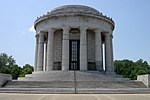
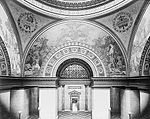
George Rogers Clark National Historical Park, located in Vincennes, Indiana, on the banks of the Wabash River at what is believed to be the site of Fort Sackville, is a United States National Historical Park. President Calvin Coolidge authorized a classical memorial and President Franklin D. Roosevelt dedicated the completed structure in 1936.
On February 25, 1779, Lieutenant Colonel George Rogers Clark, older brother of William Clark, led the capture of Fort Sackville and British Lt. Governor Henry Hamilton as part of the Illinois Campaign, which lasted from 1778 to 1779. The march of Clark's men from Kaskaskia on the Mississippi River in mid-winter and the subsequent victory over the British remains one of the most memorable feats of the American Revolution. (Full article...)Selected biography -
Wendell Lewis Willkie (born Lewis Wendell Willkie; February 18, 1892 – October 8, 1944) was an American lawyer, corporate executive and the 1940 Republican nominee for president. Willkie appealed to many convention delegates as the Republican field's only interventionist: although the U.S. remained neutral prior to Pearl Harbor, he favored greater U.S. involvement in World War II to support Britain and other Allies. His Democratic opponent, incumbent President Franklin D. Roosevelt, won the 1940 election with about 55% of the popular vote and took the electoral college vote by a wide margin.
Willkie was born in Elwood, Indiana, in 1892; both his parents were lawyers, and he also became one. He served in World War I but was not sent to France until the final days of the war, and saw no action. Willkie settled in Akron, Ohio, where he was initially employed by Firestone, but left for a law firm, becoming one of the leaders of the Akron Bar Association. Much of his work was representing electric utilities, and in 1929 Willkie accepted a job in New York City as counsel for Commonwealth & Southern Corporation (C&S), a utility holding company. He was rapidly promoted, and became corporate president in 1933. Roosevelt was sworn in as U.S. president soon after Willkie became head of C&S, and announced plans for a Tennessee Valley Authority (TVA) that would supply power in competition with C&S. Between 1933 and 1939, Willkie fought against the TVA before Congress, in the courts, and before the public. He was ultimately unsuccessful, but sold C&S's property for a good price, and gained public esteem. (Full article...)Selected quote
General images
Topics
- Economy: AM General - ATA Airlines - Casinos - Cummins - Delta - ITT - JayC - Lilly - Limestone - Manufacturing - NiSource - Shoe Carnival - Simon Property Group - Soybeans - Studebaker - Vectren - WellPoint
- Geography: Caves - Lakes - Rivers - State forests - Watersheds
Categories
Attractions
 |
Recognized content
| This is a list of recognized content, updated weekly by JL-Bot (talk · contribs) (typically on Saturdays). There is no need to edit the list yourself. If an article is missing from the list, make sure it is tagged (e.g. {{WikiProject Indiana}}) or categorized correctly and wait for the next update. See WP:RECOG for configuration options. |
Good articles
- 1963 Indiana State Fairgrounds Coliseum gas explosion
- 2006 Brickyard 400
- 2011 South Bend mayoral election
- 2015 South Bend mayoral election
- 2019 South Bend mayoral election
- 2021 NCAA Division I men's basketball championship game
- Max Bielfeldt
- The Fault in Our Stars (film)
- Hurley Goodall
- Proposed South Shore Line station in South Bend
- WCAE
Featured pictures
-
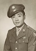
Kenje Ogata 1943
-
Kurt Vonnegut by Bernard Gotfryd (1965)
-
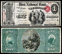
US-NBN-IL-Lebanon-2057-Orig-1-400-C
WikiProjects
State facts
Indiana | |
|---|---|
| Country | United States |
| Admitted to the Union | December 11, 1816 (19th) |
| Capital | Indianapolis |
| Largest city | Indianapolis |
| Largest metro and urban areas | Indianapolis-Carmel MSA |
| Government | |
| • Governor | Eric Holcomb (R) (2017) |
| • Lieutenant Governor | Suzanne Crouch (R) (2017) |
| Legislature | Indiana General Assembly |
| • Upper house | Senate |
| • Lower house | House of Representatives |
| U.S. senators | Todd Young (R) Mike Braun (R) |
| Population | |
| • Total | 6,080,485 |
| • Density | 169.5/sq mi (65.46/km2) |
| Language | |
| • Official language | English |
| Latitude | 37° 46′ N to 41° 46′ N |
| Longitude | 84° 47′ W to 88° 6′ W |
Things you can do
 |
Here are some tasks awaiting attention:
|
Associated Wikimedia
The following Wikimedia Foundation sister projects provide more on this subject:
-
Commons
Free media repository -
Wikibooks
Free textbooks and manuals -
Wikidata
Free knowledge base -
Wikinews
Free-content news -
Wikiquote
Collection of quotations -
Wikisource
Free-content library -
Wikiversity
Free learning tools -
Wikivoyage
Free travel guide -
Wiktionary
Dictionary and thesaurus
- ^ a b "Elevations and Distances in the United States". U.S Geological Survey. 29 April 2005. Retrieved 2006-11-06.


