
Portal:Cities
The Cities Portal

A city is a human settlement of a notable size. The term "city" has different meanings around the world and in some places the settlement can be very small. Even where the term is limited to larger settlements, there is no universally agreed definition of the lower boundary for their size. In a more narrow sense, a city can be defined as a permanent and densely settled place with administratively defined boundaries whose members work primarily on non-agricultural tasks. Cities generally have extensive systems for housing, transportation, sanitation, utilities, land use, production of goods, and communication. Their density facilitates interaction between people, government organizations, and businesses, sometimes benefiting different parties in the process, such as improving the efficiency of goods and service distribution.
Historically, city dwellers have been a small proportion of humanity overall, but following two centuries of unprecedented and rapid urbanization, more than half of the world population now lives in cities, which has had profound consequences for global sustainability. Present-day cities usually form the core of larger metropolitan areas and urban areas—creating numerous commuters traveling toward city centres for employment, entertainment, and education. However, in a world of intensifying globalization, all cities are to varying degrees also connected globally beyond these regions. This increased influence means that cities also have significant influences on global issues, such as sustainable development, climate change, and global health. Because of these major influences on global issues, the international community has prioritized investment in sustainable cities through Sustainable Development Goal 11. Due to the efficiency of transportation and the smaller land consumption, dense cities hold the potential to have a smaller ecological footprint per inhabitant than more sparsely populated areas. Therefore, compact cities are often referred to as a crucial element in fighting climate change. However, this concentration can also have significant negative consequences, such as forming urban heat islands, concentrating pollution, and stressing water supplies and other resources. (Full article...)
Selected city -

Lagos (/ˈleɪɡɒs/ LAY-goss; also US: /ˈlɑːɡoʊs/ LAH-gohss; Yoruba: Èkó) or Lagos City is the most populous city in Nigeria, with an estimated population of 21 million in 2015. Lagos is the most populous urban area in Africa. Lagos was the national capital of Nigeria until December 1991 following the government's decision to move their capital to Abuja in the centre of the country. Lagos is a major African financial centre and is the economic hub of Lagos State and Nigeria at large. The city has a significant influence on commerce, entertainment, technology, education, politics, tourism, art, and fashion in Africa. Lagos is also among the top ten of the world's fastest-growing cities and urban areas. The megacity has the fourth-highest GDP in Africa and houses one of the largest and busiest seaports on the continent. Due to the large urban population and port traffic volumes, Lagos is classified as a Medium-Port Megacity.
Lagos emerged as a home to the Awori subgroup of the Yoruba of West Africa islands, which are contained in the present day Local Government Areas (LGAs) of Lagos Island, Eti-Osa, Amuwo-Odofin and Apapa. The islands are separated by creeks, fringing the southwest mouth of Lagos Lagoon, while being protected from the Atlantic Ocean by barrier islands and long sand spits such as Bar Beach, which stretch up to 100 km (62 mi) east and west of the mouth. Due to rapid urbanisation, the city expanded to the west of the lagoon to include areas in the present day Lagos Mainland, Ajeromi-Ifelodun, and Surulere. This led to the classification of Lagos into two main areas: the Island, which was the original city of Lagos, and the Mainland, which it has since expanded into. This city area was governed directly by the Federal Government through the Lagos City Council, until the creation of Lagos State in 1967, which led to the splitting of Lagos city into the present-day seven Local Government Areas (LGAs), and an addition of other towns (which now make up 13 LGAs) from the then Western Region to form the state. (Full article...)Did you know -
- ... that Broadway's Imperial Theatre, opened in 1924, was the Shubert family's 50th theater in New York City?
- ... that two days after it had ignited, the Tiger Fire had already burned 5,567 acres (2,253 ha) of land near Black Canyon City, Arizona?
- ... that the city council of Bandung in the Dutch East Indies initially met at the site of a former coffee-packing factory?
- ... that during its planning stages, 53 West 53rd Street in New York City was shortened by 200 feet (61 m) to reduce the visibility of the mechanical rooms?
- ... that when the 18-year-old New York City Ballet dancer Mira Nadon performed her first major role, The New York Times called her performance a promise to the future?
- ... that an inquiry from an engineering student led to the repair of a structural flaw at New York City's Citicorp Center?
Related portals
Related WikiProjects
 Recognized content -

Enugu (/eɪˈnuːɡuː/ ⓘ ay-NOO-goo; Igbo: Énugwú) is the capital city of Enugu State in Nigeria. It is located inland in the Southeastern part of Nigeria. In 2006, the city had a population of 820,000 according to the last Nigerian census.
The name Enugu is derived from the two Igbo words Énú úgwú, meaning "hill top", denoting the city's hilly geography. Enugu acquired township status in 1917 and was called Enugwu-Ngwo. Because of its rapid expansion towards areas owned by other indigenous communities, the city was renamed Enugu in 1928. Since the 17th century the location of present-day Enugu has been inhabited by the Enugwu-Ngwo and Nike (/niːˈkeɪ/ nee-KAY) subgroups of the Igbo people. (Full article...)Selected article -

The French Quarter, also known as the Vieux Carré, is the oldest neighborhood in the city of New Orleans. After New Orleans (French: Nouvelle-Orléans) was founded in 1718 by Jean-Baptiste Le Moyne de Bienville, the city developed around the Vieux Carré ("Old Square" in English), a central square. The district is more commonly called the French Quarter today, or simply "The Quarter", related to changes in the city with American immigration after the 1803 Louisiana Purchase. Most of the extant historic buildings were constructed either in the late 18th century, during the city's period of Spanish rule, or were built during the first half of the 19th century, after U.S. purchase and statehood.
The district as a whole has been designated as a National Historic Landmark, with numerous contributing buildings that are separately deemed significant. It is a prime tourist destination in the city, as well as attracting local residents. Because of its distance from areas where the levee was breached during Hurricane Katrina in 2005 as well as the strength and height of the nearest Mississippi River Levees in contrast to other levees along the canals and lakefront, it suffered relatively light damage from floodwater as compared to other areas of the city and the greater region. (Full article...)General images -
-
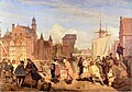 Gdańsk in the 17th century (from History of cities)
 -
 This woodcut shows Nuremberg as a prototype of a flourishing and independent city in the 15th century. (from History of cities)
 -
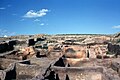 Excavated foundations of Çatalhöyük, Turkey. An Anatolian town dated to 7000 BCE. (from History of cities)
 -
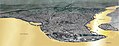 Constantinople, the largest and wealthiest city in Europe from the 9th through the 12th century (from History of cities)
 -
-
 The city of Arbil in the Kurdistan Region of Iraq has a radial urban structure centred on an ancient fortress (from Urban structure)
 -
 Daily life of people from the Song period at the capital, Bianjing, today's Kaifeng (from History of cities)
 -
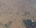
 Aerial photograph shows the remains of the Sumerian city Ur, near Nasiriyah, Iraq. (from History of cities)
 -
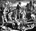 Cain founding the city of Enoch (from History of cities)
 -
 A poster from the EPA entitled "Soak Up the Rain with Green Infrastructure." The poster depicts various green infrastructure that can be effective in preventing floods. (from Urban geography)
 -
 The Round city of Baghdad, the capital of Iraq (from History of cities)
 -
-
 Extent and major sites of the Indus Valley civilization of ancient India (from History of cities)
 -
 View of the Agora of Athens with the temple of Hephaestus to the left and the Stoa of Attalos to the right (from History of cities)
 -
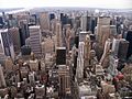 New York City, one of the largest urban areas in the world (from Urban geography)
 -
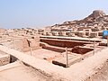 Mohenjo-daro, a World Heritage Site that was part of the Indus Valley civilization (from History of cities)
 -
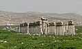
 Palmanova, Italy, constructed in 1593 according to the defensive ideal of the star fort, today retains its distinctive geometry. (from History of cities)
 -
 A map showing the world energy consumption per capita based on 2013 data from the World Bank. (from Urban geography)
 -
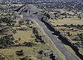 The Avenue of the Dead in Teotihuacan originates with the Pyramid of the Moon, forming the basis of the city grid. (from History of cities)


.jpg)


_LACMA_M.2008.40.98.8.jpg)


Topics
List articles
Subcategories

Associated Wikimedia
The following Wikimedia Foundation sister projects provide more on this subject:
-
 Commons
Free media repository -
 Wikibooks
Free textbooks and manuals -
 Wikidata
Free knowledge base -
 Wikinews
Free-content news -
 Wikiquote
Collection of quotations -
 Wikisource
Free-content library -
 Wikiversity
Free learning tools -
 Wiktionary
Dictionary and thesaurus


