
Portal:Honduras
The Honduras Portal

Republic of Honduras República de Honduras (Spanish) | |
|---|---|
Motto:
| |
| ISO 3166 code | HN |


Honduras, officially the Republic of Honduras, is a country in Central America. Honduras is bordered to the west by Guatemala, to the southwest by El Salvador, to the southeast by Nicaragua, to the south by the Pacific Ocean at the Gulf of Fonseca, and to the north by the Gulf of Honduras, a large inlet of the Caribbean Sea. Its capital and largest city is Tegucigalpa.
Honduras was home to several important Mesoamerican cultures, most notably the Maya, before the Spanish colonization in the sixteenth century. The Spanish introduced Catholicism and the now predominant Spanish language, along with numerous customs that have blended with the indigenous culture. Honduras became independent in 1821 and has since been a republic, although it has consistently endured much social strife and political instability, and remains one of the poorest countries in the Western Hemisphere. In 1960, the northern part of what was the Mosquito Coast was transferred from Nicaragua to Honduras by the International Court of Justice.
The nation's economy is primarily agricultural, making it especially vulnerable to natural disasters such as Hurricane Mitch in 1998. The lower class is primarily agriculturally based while wealth is concentrated in the country's urban centers. Honduras has a Human Development Index of 0.625, classifying it as a nation with medium development. When adjusted for income inequality, its Inequality-adjusted Human Development Index is 0.443. (Full article...)
Selected article -

Lake Yojoa is the largest lake in Honduras with a surface area of 79 square kilometers (31 square miles) and an average depth of 15 meters (49 feet). At an altitude of 700 meters (2,300 feet), it lies in a depression formed by volcanoes. The Lake Yojoa volcanic field consists of Pleistocene to Holocene scoria cones, craters, and lava flows.
The west side of the lake is bordered by steep mountains and Santa Bárbara National Park while the east side is adjacent to Cerro Azul Meambar National Park. The lake is situated on the highway that connects the two largest Honduran cities, Tegucigalpa and San Pedro Sula. For many people traveling between the cities, the lake serves as a rest area where they can appreciate the view and enjoy the fresh fried fish and other foods that are offered by the restaurants located on its banks. (Full article...)Interesting facts -
- ... that the Honduran Patriotic Front, an alliance formed ahead of the 1980s elections, called for an electoral boycott in protest against perceived fraud?
- ... that a river in Honduras swelled 15 meters (50 feet) above its normal level during torrential rains from a hurricane in 1935?
- ... that when the British Honduran Lands Department claimed no lands were available for women, Gwendolyn Lizarraga marched into the swamp and measured lots to create land parcels?
- ... that infighting among the conquistadors hindered the Spanish conquest of Honduras?
Related portals
General images -
-
 Xiomara Castro became the first woman to gain a presidential charge in Honduras. (from History of Honduras)
 -
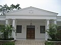
 National Theater and opera, Manuel Bonilla (from Culture of Honduras)
 -
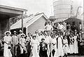
 European pirates, especially British, French, and Dutch attacked Honduran towns during the colonial era.
 -
 First coat of arms of Honduras given by the emperor Charles I of Spain an 5th of the Holy Roman empire. By the time of the colonial era Honduras suffered a demographic change due the arrival of Spanish immigrants (from History of Honduras)
 -
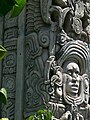 Mayan stellae. (from Culture of Honduras)
 -
 American troops arriving in Honduras in 1988 during Operation Golden Pheasant. (from History of Honduras)
 -
 Pork chop with plantain chips. (from Honduran cuisine)
 -
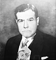
 President Manuel Bonilla. (from History of Honduras)
 -
 Traditional dance of Honduras. (from Culture of Honduras)
 -
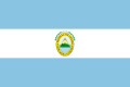 Flag of the Central American Federation that lasted until 1839. (from History of Honduras)
 -
 Holy Week in Honduras. (from Culture of Honduras)
 -
 Sopa de caracol (conch soup) (from Honduran cuisine)
 -
 Honduran Police in San Francisco, Lempira (from Crime in Honduras)
 -
 Cafe Guancasco, is one of the best exponents of Honduran pop rock. (from Culture of Honduras)
 -
 Old presidential palace of Honduras. (from History of Honduras)
 -
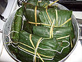 The nacatamal a prehispanic dish widely consumed in Honduras. (from Culture of Honduras)
 -

-
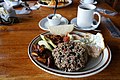
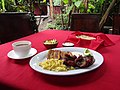 A Honduran breakfast (from Honduran cuisine)
 -
 Juan Carlos Fanconi, Film Director (from Culture of Honduras)
 -
 In 1986 Honduras bombed two Nicaraguan towns. (from History of Honduras)
 -
 Roger Espinoza (from Culture of Honduras)
 -
 Actress America Ferrera. (from Culture of Honduras)
 -
 The dictatorship of Carias Andino is remembered as the longest dictatorship that Honduras has ever had (from History of Honduras)
 -
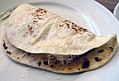 An homemade baleada with eggs, butter, cheese and beans (from Honduran cuisine)
 -
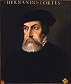 After the fall of Tenochtitlan, Hernán Cortés made his journey to the region of las Hibueras, modern day Honduras. (from History of Honduras)
 -
 Map of the town of Trujillo from the 16th century. (from History of Honduras)
 -
 Casamiento, a rice and beans dish (from Honduran cuisine)
 -
 San Cristóbal fortress, in the city of Gracias, built during the 19th century. (from History of Honduras)
 -

-
 La Merced plaza of Comayagua after the independence from Spain. (from History of Honduras)
 -

-
 Lencan cloth. (from Culture of Honduras)
 -
 Honduran armed conflict of 1907. (from History of Honduras)
 -
 The Virgin of Suyapa (from Culture of Honduras)
 -
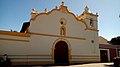 The church of la Merced in the city of Comayagua was the first Cathedral of Honduras in 1550 and is the oldest Honduran church still standing. (from History of Honduras)
 -
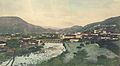 Tegucigalpa in 1910. (from History of Honduras)
 -
 Diablos Negros, is a Honduran hard Rock band active since the 1980s. (from Culture of Honduras)
 -
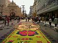 Sawdust carpet in Holy Week. (from Culture of Honduras)
 -
 Emilio Izaguirre (from Culture of Honduras)
 -
 One of the Pyramids of Los Naranjos, considered the oldest structures of Honduras.
 -
 Painting depicting the chief Lempira fighting against a conquistador (from History of Honduras)
 -
 Tela's railroad company building, built in 1919. (from History of Honduras)
 -
 City of Comayagüela in the 2010s (from History of Honduras)
 -
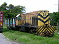
 Oldest train still preserved in Honduras. (from History of Honduras)
 -
 Tegucigalpa after the Mitch Hurricane. (from History of Honduras)
 -
 The railroad transportation suffered a lot of economic issues and disadvantages during the 2000s, it was not until 2010 passenger trains where reactivated. (from History of Honduras)
 -
 Fried fish from Lake Yojoa (from Honduran cuisine)
 -
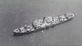 The SS Contessa, a Honduran ship that participated in the Operation Torch in the north African campaign in the Second World War. (from History of Honduras)
 -
 Lenca vessel from the Classic period depicting an ear of corn in its sheath (from Honduran cuisine)
 -
 Port of Amapala. (from History of Honduras)
 -
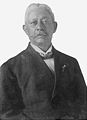
 General Luis Bogran. (from History of Honduras)
 -
 Maguen David sinagoge in San Pedro Sula, one of the places of the Honduran Jewish community. (from Culture of Honduras)
 -
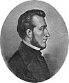 Central American president General Francisco Morazán Quezada.
 -
 Honduran National Congress, built during the 1950s (from History of Honduras)
 -
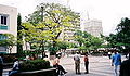 Central Park in San Pedro Sula, where several cultural events take place throughout the year. (from Culture of Honduras)
 -
 Coat of Arms of Trujillo, one of the oldest towns founded by the Spanish in Honduras.
 -
 Coat of arms of the Miskito royal family. (from History of Honduras)
 -
 Cathedral of Saint Michael Archangel in Tegucigalpa was built during the XVIII century. (from History of Honduras)
 -
 Graifuna traditional dance. (from Culture of Honduras)
 -
 Train station in La Ceiba during the 1920s. The locomotives were one of the main means of transportation in Honduras during the 20th century. (from History of Honduras)
 -
 Pyramid 102 of Yarumela, one of the oldest Honduran archeological sites. (from History of Honduras)
 -
 Wilson Palacios (from Culture of Honduras)
 -
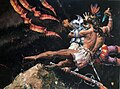
 Mayan rain god Chaac representation at the Mayan Sculpture Museum in Copán. (from Culture of Honduras)
 -
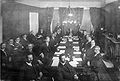 The Central American peace conference in 1907. (from History of Honduras)
 -
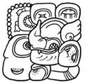 Mayan representative hieroglyphic of the Yax Kuk Mo Dynasty that later would become the emblem of the Kingdom of "Oxwitik" also known as Copán. (from History of Honduras)
 -
 After the 2009 coup d'état, the military presence in the streets began to be more common. (from History of Honduras)
 -
 The Fortress of San Fernando de Omoa (from History of Honduras)
 -
 Honduran Police in a rural area. (from Crime in Honduras)
 -
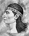 Lempira, Lenca leader and war lord. (from Culture of Honduras)
 -
 Footballer Porfirio Betancourt, 1981, one of the first hispanic players for the NASL. (from Culture of Honduras)
 -
 David Suazo. (from Culture of Honduras)
 -
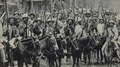
 Honduran army in 1926. (from History of Honduras)
 -
 Group of dancers with typical costumes from Honduras. (from Culture of Honduras)
 -
 Sir Salvador Moncada. Honduran pharmacologyst. (from Culture of Honduras)
 -
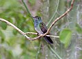 Honduran emerald (Amazilia luciae) (from Flora and fauna of Honduras)
 -
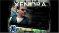 El Xendra is an independent film that mixes elements of suspense and science fiction. (from Culture of Honduras)
 -
The baleada is a popular Honduran fast food dish. (from Culture of Honduras)
-
 Pre Columbian pottery. (from Culture of Honduras)
 -
Typical Honduran breakfast. (from Culture of Honduras)
.jpg)


.svg)


.jpg)


_(cropped).jpg)


.jpg)


_(2495402213).jpg)


List articles

- Departments of Honduras
- List of cathedrals in Honduras
- List of companies of Honduras
- List of ecoregions in Honduras
- List of football clubs in Honduras
- List of Honduran departments by Human Development Index
- List of Hondurans
- List of Honduras-related topics
- List of national parks of Honduras
- List of political parties in Honduras
- List of presidents of Honduras
- List of rivers of Honduras
- List of wars involving Honduras
- Municipalities of Honduras
- Outline of Honduras
- Timeline of Tegucigalpa
Largest cities or towns
Largest cities or towns in Honduras According to the 2013 Census[1]
| |||||||||||||||||||||||||||||||||||||||||||||||
|---|---|---|---|---|---|---|---|---|---|---|---|---|---|---|---|---|---|---|---|---|---|---|---|---|---|---|---|---|---|---|---|---|---|---|---|---|---|---|---|---|---|---|---|---|---|---|---|
| |||||||||||||||||||||||||||||||||||||||||||||||


Categories

Politics articles
Map

Get involved
See WikiProject Honduras for editor resources and to collaborate with other editors on improving Wikipedia's Honduras-related articles.
Need help?
Do you have a question about Honduras that you can't find the answer to? Consider asking it at the Wikipedia reference desk.
Tasks
 |
Here are some tasks awaiting attention:
|
Did you know...
No recent additions
Associated Wikimedia
The following Wikimedia Foundation sister projects provide more on this subject:
-
 Commons
Free media repository -
 Wikibooks
Free textbooks and manuals -
 Wikidata
Free knowledge base -
 Wikinews
Free-content news -
 Wikiquote
Collection of quotations -
 Wikisource
Free-content library -
 Wikiversity
Free learning tools -
 Wikivoyage
Free travel guide -
 Wiktionary
Dictionary and thesaurus


