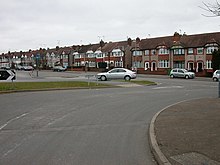
Coundon, Coventry

Coundon is a predominantly residential suburb in north-west Coventry, West Midlands, England.[1]
Along with the neighbouring Keresley, Coundon was originally a village in the Warwickshire countryside. By the 1930s it had been incorporated into the city of Coventry after mass housebuilding took place to accommodate the city's growing population.[2]
History[edit]
Coundon was one of the few villages that are now part of Coventry to be mentioned in the Domesday Book (1086).[3] Holy Trinity Church had land in Coundon from at least the early 14th century. In 1410-11 Coundon was divided into Old, or Little Coundon, and New Coundon and it was part of the Knightlow Hundred until 1451.[4]

Coundon was described as a parish in 1801 and 1811 and as a hamlet until 1881.[4] The cycle manufacturer George Singer of Singer & Co built Coundon Court on land that was formerly part of Coundon Farm in 1891. It was constructed in the Victorian Gothic style.[5] The house is now part of the site of Coundon Court Secondary School and is referred to as 'The Old House'.

Alvis Motors opened it's first factory on the Holyhead Road in Coundon, in 1919 and originally produced stationary engines and motor scooters. It expanded to produce four-cylinder engines, six-cylinder engines, and large six-cylinder cars so a larger car factory was built on a 29 acre site. During the Coventry Blitz in World War Two the larger factory was severely damaged by the German Luftwaffe’s bombing[6] and car production was then suspended until 1946. In 1965 Alvis came under the control of Rover, and production was moved out of Coventry in 1999. Alvis employed around 2,400 people at its peak.[7] The site of the former factory in Coundon is now the Alvis Retail Park.
The Rialto picture house was opened on Moseley Avenue in 1928, showing silent films with accompaniment by a pianist and small orchestra of two violins, two double bass, trumpet, trombone and drums on one level of the building, and with a ballroom on another level of the building.[3] The cinema was destroyed during in the Coventry Blitz but the ballroom survived and became the Rialto Bingo Club. The venue operates today as the Rialto Plaza, hosting live music events.[8]
The Holyhead Pub began operating in 1929 on the Holyhead Road, the coaching road from London to Holyhead.[9] The Nugget Pub was built in 1938 in anticipation of housing development on Coundon Wedge, which never happened.[10]
From 1951 to 2005, Coundon was the location of the Browns Lane Jaguar car factory, which for its first 47 years was the carmaker's only plant. Upon its closure in 2005, production of cars was split between factories in Castle Bromwich and Halewood, and the Browns Lane plant was largely demolished in 2008, although part of the site remains under Jaguar ownership, and some is now used by a vehicle interiors manufacturer.
Amenities[edit]


- Coundon Community Library, open Monday to Saturday.[11]
- Coundon Community Peace Orchard at Coundon Hall Park.[12]
- Coundon Wedge, an open space that forms a wedge of open land between the built up residential areas of Coundon and Allesley.[13]
- The Old Hall Hotel, an 1840’s country house, which is now a wedding venue with a restaurant and bar facilities.[14]
Education[edit]
Several schools are situated in the suburb of Coundon. These are Coundon Primary School, Hollyfast Primary School, Moseley Primary School, Christ the King Infant and Junior Schools (separated into different locations) and Coundon Court Secondary School. The playing fields of Bablake School, an independent school, are located in Coundon.[15]
Politics[edit]
Coundon is split across two wards, Sherbourne ward to the South West and Bablake ward to the North.[16] Three councillors represent each ward, three of whom are members of the Labour Party. In Bablake ward, there are two Conservative Party Councillors and one Independent.
In general elections Coundon falls within the constituency of Coventry North West, which returns one Member of Parliament; currently Taiwo Owatemi of the Labour Party.[17]
References[edit]
- ^ AA Street by Street. Coventry Rugby (2nd edition (May 2003) ed.). AA Publishing. 2 January 2004. p. 22. ISBN 0-7495-3973-9.
- ^ A Brief History Of Keresley And Coundon
- ^ a b "Information on the Coundon area of Coventry". The Coventry Society. Retrieved 7 June 2024.
- ^ a b "The City of Coventry: The outlying parts of Coventry, Coundon | British History Online". www.british-history.ac.uk. Retrieved 7 June 2024.
- ^ "Our History - Coundon Court School". www.coundoncourt.org. Retrieved 7 June 2024.
- ^ "Alvis Car Company - Our Heritage". Alvis. Retrieved 7 June 2024.
- ^ Mullen, Enda (18 November 2018). "Alvis: The amazing history of a legendary Coventry car maker". Coventry Live. Retrieved 7 June 2024.
- ^ "Events". Rialto Plaza. Retrieved 7 June 2024.
- ^ "Coventry's Pub History: Holyhead, Holyhead Road". pubhistory.historiccoventry.co.uk. Retrieved 7 June 2024.
- ^ "Coventry's Pub History: Nugget, Coundon Green". pubhistory.historiccoventry.co.uk. Retrieved 7 June 2024.
- ^ "Coundon Library - Libraries". Coventry City Council. Retrieved 7 June 2024.
- ^ "Home". Coventry Community Peace Orchard. Retrieved 7 June 2024.
- ^ "Coundon Wedge". www.denspages.co.uk. Retrieved 7 June 2024.
- ^ "Luxury Hotel in Coventry, Warwickshire and The West Midlands". The Old Hall Hotel. Retrieved 7 June 2024.
- ^ "School Maps". Bablake School. Retrieved 7 June 2024.
- ^ "Coventry City Council: Sherbourne". Archived from the original on 29 November 2010. Retrieved 16 August 2010.
- ^ "Coventry City Council: Bablake". Archived from the original on 27 November 2010. Retrieved 16 August 2010.
