
Portal:Cities
The Cities Portal

A city is a human settlement of a notable size. The term "city" has different meanings around the world and in some places the settlement can be very small. Even where the term is limited to larger settlements, there is no universally agreed definition of the lower boundary for their size. In a more narrow sense, a city can be defined as a permanent and densely settled place with administratively defined boundaries whose members work primarily on non-agricultural tasks. Cities generally have extensive systems for housing, transportation, sanitation, utilities, land use, production of goods, and communication. Their density facilitates interaction between people, government organizations, and businesses, sometimes benefiting different parties in the process, such as improving the efficiency of goods and service distribution.
Historically, city dwellers have been a small proportion of humanity overall, but following two centuries of unprecedented and rapid urbanization, more than half of the world population now lives in cities, which has had profound consequences for global sustainability. Present-day cities usually form the core of larger metropolitan areas and urban areas—creating numerous commuters traveling toward city centres for employment, entertainment, and education. However, in a world of intensifying globalization, all cities are to varying degrees also connected globally beyond these regions. This increased influence means that cities also have significant influences on global issues, such as sustainable development, climate change, and global health. Because of these major influences on global issues, the international community has prioritized investment in sustainable cities through Sustainable Development Goal 11. Due to the efficiency of transportation and the smaller land consumption, dense cities hold the potential to have a smaller ecological footprint per inhabitant than more sparsely populated areas. Therefore, compact cities are often referred to as a crucial element in fighting climate change. However, this concentration can also have significant negative consequences, such as forming urban heat islands, concentrating pollution, and stressing water supplies and other resources. (Full article...)
Selected city -
.jpg)
Budapest is the capital and most populous city of Hungary. It is the ninth-largest city in the European Union by population within city limits and it was the largest city on the Danube river; today it is the second largest one. The city has an estimated population of 1,752,286 over a land area of about 525 square kilometres (203 square miles). Budapest, which is both a city and municipality, forms the centre of the Budapest metropolitan area, which has an area of 7,626 square kilometres (2,944 square miles) and a population of 3,303,786. It is a primate city, constituting 33% of the population of Hungary.
The history of Budapest began when an early Celtic settlement transformed into the Roman town of Aquincum, the capital of Lower Pannonia. The Hungarians arrived in the territory in the late 9th century, but the area was pillaged by the Mongols in 1241–42. Re-established Buda became one of the centres of Renaissance humanist culture by the 15th century. The Battle of Mohács, in 1526, was followed by nearly 150 years of Ottoman rule. After the reconquest of Buda in 1686, the region entered a new age of prosperity, with Pest-Buda becoming a global city after the unification of Buda, Óbuda and Pest on 17 November 1873, with the name 'Budapest' given to the new capital. Budapest also became the co-capital of the Austro-Hungarian Empire, a great power that dissolved in 1918, following World War I. The city was the focal point of the Hungarian Revolution of 1848 and the Battle of Budapest in 1945, as well as the Hungarian Revolution of 1956. (Full article...)Did you know -
- ... that the New York City government sought to demolish a wall around the Isaac L. Rice Mansion for five years?
- ... that when Jo Ann Evansgardner ran for a position on the Pittsburgh City Council, she asked voters to "put this woman in her place"?
- ... that the RKO Keith's Theater, once described as one of New York City's "great theaters", later stood in ruins and was covered with graffiti?
- ... that while 1271 Avenue of the Americas was being built at New York City's Rockefeller Center, Marilyn Monroe re-launched the Center's long-dormant "Sidewalk Superintendents' Club"?
- ... that the bamboo-filled atrium of the IBM Building was described as "New York City's peerless privately owned public space"?
- ... that one of the longest civil trials in Utah history, with 1,000 exhibits, concerned the purchase of a Salt Lake City TV station?
Related portals
Related WikiProjects
 Recognized content -

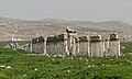
Hisar pronunciation also known as Hissar is the administrative headquarters of Hisar district in the state of Haryana in northwestern India. It is located 164 km (102 mi) to the west of New Delhi, India's capital, and has been identified as a counter-magnet city for the National Capital Region to develop as an alternative center of growth to Delhi.
The city was ruled by several major powers, including the Mauryans in the third century BC, the Tughlaqs in the 14th century, the Mughals in the 16th century, and the British in the 19th century. After India achieved independence, it was unified with the state of Punjab. When the Punjab was divided in 1966, Hisar became part of Haryana. (Full article...)Selected article -

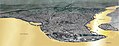
The Melbourne central business district (also known colloquially as simply "the City" or "the CBD") is the city centre and main urban area of the city of Melbourne, Victoria, Australia, centred on the Hoddle Grid, the oldest part of the city laid out in 1837, and includes its fringes. The Melbourne CBD is located mostly in the local government area of the City of Melbourne, which also includes some of inner suburbs adjoining the CBD, while a small section extends into the City of Port Phillip.
The contemporary locality of Melbourne includes within its boundaries the Hoddle Grid plus the area of parallel streets just to the north up to Victoria Street including the Queen Victoria Market, but not the Flagstaff Gardens, and the area between Flinders Street and the Yarra River. It includes the grand boulevardes of St Kilda Road, Royal Parade and Victoria Street marking the entrance to Victoria Parade as well as extensive gardens including the Melbourne Botanical Gardens and Jolimont Yard. (Full article...)General images -
-
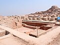 Mohenjo-daro, a World Heritage Site that was part of the Indus Valley civilization (from History of cities)
 -
 Excavated foundations of Çatalhöyük, Turkey. An Anatolian town dated to 7000 BCE. (from History of cities)
 -
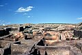
 Aerial photograph shows the remains of the Sumerian city Ur, near Nasiriyah, Iraq. (from History of cities)
 -
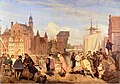
 Daily life of people from the Song period at the capital, Bianjing, today's Kaifeng (from History of cities)
 -
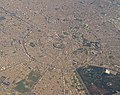
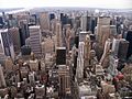 New York City, one of the largest urban areas in the world (from Urban geography)
 -
 Extent and major sites of the Indus Valley civilization of ancient India (from History of cities)
 -
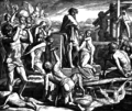 Cain founding the city of Enoch (from History of cities)
 -
 Palmanova, Italy, constructed in 1593 according to the defensive ideal of the star fort, today retains its distinctive geometry. (from History of cities)
 -
 The Round city of Baghdad, the capital of Iraq (from History of cities)
 -
-
 Constantinople, the largest and wealthiest city in Europe from the 9th through the 12th century (from History of cities)
 -
 This woodcut shows Nuremberg as a prototype of a flourishing and independent city in the 15th century. (from History of cities)
 -
 A poster from the EPA entitled "Soak Up the Rain with Green Infrastructure." The poster depicts various green infrastructure that can be effective in preventing floods. (from Urban geography)
 -
 The city of Arbil in the Kurdistan Region of Iraq has a radial urban structure centred on an ancient fortress (from Urban structure)
 -
-
 A map showing the world energy consumption per capita based on 2013 data from the World Bank. (from Urban geography)
 -
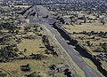 The Avenue of the Dead in Teotihuacan originates with the Pyramid of the Moon, forming the basis of the city grid. (from History of cities)
 -
 Gdańsk in the 17th century (from History of cities)
 -
 View of the Agora of Athens with the temple of Hephaestus to the left and the Stoa of Attalos to the right (from History of cities)


.jpg)


_LACMA_M.2008.40.98.8.jpg)


Topics
List articles
Subcategories

Associated Wikimedia
The following Wikimedia Foundation sister projects provide more on this subject:
-
 Commons
Free media repository -
 Wikibooks
Free textbooks and manuals -
 Wikidata
Free knowledge base -
 Wikinews
Free-content news -
 Wikiquote
Collection of quotations -
 Wikisource
Free-content library -
 Wikiversity
Free learning tools -
 Wiktionary
Dictionary and thesaurus


