
Portal:Western Australia
Introduction
 Western Australia (commonly abbreviated as WA) is a state of Australia occupying the western third of the land area of Australia, excluding external territories. It is bounded by the Indian Ocean to the north and west, the Southern Ocean to the south, the Northern Territory to the north-east, and South Australia to the south-east. With a total land area of 2,527,013 square kilometres (975,685 sq mi), Western Australia is Australia's largest state as well as the second-largest subdivision of any country on Earth, surpassed only by the Sakha Republic in eastern Russia. the state has 2.76 million inhabitants—11 percent of the national total. The vast majority (92 percent) live in the south-west corner; 79 percent of the population lives in the Perth area, leaving the remainder of the state sparsely populated. The first Europeans to visit Western Australia belonged to the Dutch Dirk Hartog expedition, who visited the Western Australian coast in 1616. The first permanent European colony in what is today Western Australia occurred following the landing by Major Edmund Lockyer on 26 December 1826 of an expedition on behalf of the New South Wales colonial government. Lockyer established a convict-supported military garrison at King George III Sound, at present-day Albany, and on 21 January 1827 he formally took possession for the British Crown of the western part of the continent that was not already claimed by the Crown. This was followed by the establishment of the Swan River Colony in 1829, including the site of the present-day capital, Perth. (Full article...)
|


(Northern
Territory) |
 Good articles -
-
 Linda Yunkata Syddick Napaltjarri (born c. 1937) is a Pintupi- and Pitjantjatjara- speaking Indigenous artist from Australia's Western Desert region. Her father was killed when she was young; her mother later married Shorty Lungkarta Tjungarrayi, an artist whose work was a significant influence on Linda Syddick's painting.
Linda Syddick was one of many Western Desert women who took up painting in the early 1990s, as part of a broader contemporary Indigenous Australian art movement. She began painting some time prior to 1991, when her work was first exhibited in Alice Springs. Her work includes a distinctive fusion of Christian and Aboriginal traditional themes and motifs. She has been a finalist in the National Aboriginal & Torres Strait Islander Art Awards on at least four occasions, and in the Blake Prize (a religious art competition) at least three times. Her works are held by numerous galleries including the National Gallery of Australia, the Art Gallery of New South Wales and the Art Gallery of South Australia. Linda Syddick was the subject of a portrait painted by Robert Hannaford, which was a 1992 finalist in Australia's premiere portrait competition, the Archibald Prize. (Full article...) -
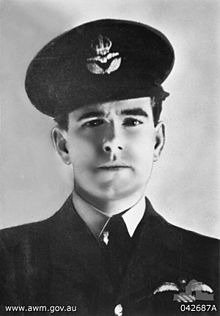
Air Commodore Sir Hughie Idwal Edwards, VC, KCMG, CB, DSO, OBE, DFC (1 August 1914 – 5 August 1982) was a senior officer in the Royal Air Force, Governor of Western Australia, and an Australian recipient of the Victoria Cross, the highest decoration for gallantry "in the face of the enemy" that can be awarded to members of the British and Commonwealth armed forces. Serving as a bomber pilot in the Royal Air Force (RAF), Edwards was decorated with the Victoria Cross in 1941 for his efforts in leading a bombing raid against the port of Bremen, one of the most heavily defended towns in Germany. He became the most highly decorated Australian serviceman of the Second World War.
Born in Fremantle, Western Australia, Edwards joined the Royal Australian Air Force in 1935, and a year later was granted a short service commission with the RAF. Serving throughout the Second World War, he gained a permanent commission and continued his career in the RAF after the war; he retired in 1963 with the rank of air commodore. Returning to Australia, he was appointed Governor of Western Australia in 1974. (Full article...) -
Daglish is a small western suburb of Perth, the capital of Western Australia. It is approximately 4 kilometres (2.5 mi) west of the Perth central business district, and within the City of Subiaco local government area. It was named after Henry Daglish, who was the mayor of Subiaco, member for the electoral district of Subiaco and premier of Western Australia from 1904 to 1905. The Daglish railway station opened in 1924 in response to population growth in the neighbouring suburb of Subiaco. The following year, the Municipality of Subiaco bought the land west of the railway station to sell for housing. Development occurred over the following 20 years. The initial development next to the railway station used the garden suburb principles, with large lots and gardens, curved streets, and lots of green space. Today, the suburb has significant heritage value due to its uniform streetscape, with most original homes still standing. It has a population of 1,419 as of the 2016 Australian census. (Full article...) -
Greenwood railway station is a park and ride suburban railway station in Perth, Western Australia, within the suburbs of Duncraig and Greenwood. The station is on the Joondalup line and is part of the Transperth network. Located within the median strip of the Mitchell Freeway at an interchange with Hepburn Avenue, Greenwood station consists of two side platforms connected to a car park east of the freeway by a footbridge.
The station was included within early plans for the Joondalup line in the 1980s, but the final plan for the Joondalup line, which opened in December 1992, did not include the construction of Greenwood station. After several promises by the state government during the 1990s to build the station, a A$6.8 million contract was awarded to John Holland Group in February 2004 to construct the station. Construction began in March 2004, and the station opened on 29 January 2005, relieving pressure on the car parks at Warwick and Whitfords stations. (Full article...) -
Council House is a 13-storey office building on St Georges Terrace in Perth, Western Australia. Located beside Stirling Gardens and Government House in the city's central business district, the 49.8-metre (163 ft) building was designed by Howlett and Bailey Architects and opened by Queen Elizabeth II in 1963, after Perth hosted the 1962 British Empire and Commonwealth Games. For most of its history, it has served as the headquarters for the City of Perth.
Built in a modernist style, the building has been the subject of vigorous public debate about its heritage value. Some parties, such as the Royal Australian Institute of Architects, consider the building to be an important example of modernist architecture in the city, whilst others consider it ugly. These conflicting views led to animosity in the 1990s, when the State Government refused to heritage list the property, and instead recommended its demolition. Despite this, the City of Perth opted to renovate the tower and keep it as its headquarters. Following this, the building was admitted to the State's Heritage Register. (Full article...) -
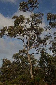
Eucalyptus wandoo, commonly known as wandoo, dooto, warrnt or wornt and sometimes as white gum, is a small to medium-sized tree that is endemic to the southwest of Western Australia. It has smooth bark, lance-shaped adult leaves, flower buds in groups of nine to seventeen, white flowers and conical to cylindrical fruit. It is one of a number of similar Eucalyptus species known as wandoo.
E. wandoo was first described in 1934 by the Australian botanist William Faris Blakely in his book A Key to the Eucalypts using material collected by the English collector Augustus Frederick Oldfield from a sand plain along the Kalgan River. , Plants of the World Online lists Eucalyptus redunca var. elata as a taxonomic synonym of E. wandoo. (Full article...) -
The Mitchell Freeway is a 41.5-kilometre-long (25.8 mi) freeway in the northern suburbs of Perth, Western Australia, linking central Perth with the city of Joondalup. It is the northern section of State Route 2, which continues south as Kwinana Freeway and Forrest Highway. Along its length are interchanges with several major roads, including the Graham Farmer Freeway and Reid Highway. The southern terminus of the Mitchell Freeway is at the Narrows Bridge, which crosses the Swan River, and the northern terminus is at Romeo Road in Alkimos.
Planning for the route began in the 1950s, and the first segment in central Perth was constructed between 1967 and 1973. Named after Sir James Mitchell, the freeway has been progressively extended north since then. In the 1970s, the first two extensions were completed, up to Hutton Street in Osborne Park. By the end of the 1980s, the freeway had reached Ocean Reef Road in Edgewater. The Joondalup railway line was constructed in the freeway median in the early 1990s. This necessitated the relocation of a section of the southbound carriageway, and the construction of three new bridges. In conjunction with these works, additional lanes were constructed in the realigned section. (Full article...) -

The western rosella (Platycercus icterotis), or moyadong, is a species of parrot endemic to southwestern Australia. The head and underparts are bright red, and the back is mottled black; a yellow patch at the cheek distinguishes it from others of the genus Platycercus. Adults of the species exhibit sexual dimorphism with the females duller overall; juveniles lack the striking colours of mature birds and the characteristic patterning is not as easily distinguished. Their communication call is a softly delivered pink-pink sound, and much of their behaviour is comparatively unobtrusive. Their habitat is in eucalypt forests and woodlands, where they often remain unobserved until they appear to feed on seeds at nearby cleared areas.
Individuals form mating pairs and generally remain in one locality, although they will venture out to join small groups at plentiful sources of food. The western rosella is predominantly herbivorous, its diet consisting mostly of seeds of grasses and other plants, although nectar and insect larvae are sometimes eaten. The damage attributed to the species at introduced fruit and grain crops saw them declared as a pest and permitted by the state to be killed or captured. They are more placid and sociable than rosellas of other Australian regions from which they are geographically isolated and have become internationally popular as an aviary bird. Their history in aviculture begins with two 1830 lithographs of live specimens in England by Edward Lear. Successful breeding in captivity began there during the early 20th century. (Full article...) -
Perth Underground railway station is a railway station within the Perth central business district in Western Australia. It is adjacent to the above-ground Perth railway station and is sometimes considered part of that station. Perth Underground station is served by Joondalup line services heading north and Mandurah line services heading south. It was built as part of the construction for the Mandurah line and was known as William Street station during construction due to its location on William Street. Perth Underground station consists of an island platform and a concourse below ground. There are five entrances to the station: from Murray Street Mall, Raine Square, 140 William Street, underneath the Horseshoe Bridge, and from Perth station.
The contract for Package F of the Mandurah line, which included the construction of Perth Underground station, Elizabeth Quay station (known as Esplanade station prior to 2016), 700 metres (2,300 ft) of bored tunnels and 600 metres (2,000 ft) of cut-and-cover tunnels, was awarded to Leighton Contractors and Kumagai Gumi in February 2004 at a cost of A$324.5 million. Demolition of buildings on the Perth Underground site occurred between April and August 2004. From September 2004 to January 2005, the station's diaphragm walls were constructed. By the end of 2005, the station box had been excavated to its lowest level, and in February 2006, the tunnel boring machine (TBM) reached the station, having tunnelled from Esplanade station. From there, the TBM tunnelled north. The TBM reached the station again in August 2006 while digging the second tunnel, and it again tunnelled north to surface west of Perth station. (Full article...) -
The Causeway is an arterial traffic crossing in Perth, Western Australia, linking the inner-city suburbs of East Perth and Victoria Park. It is carried over the Swan River at the eastern end of Perth Water by two bridges on either side of Heirisson Island. The current Causeway is the third structure to have been built across the river at this point.
Originally the site of mudflats which restricted river navigation, the Colony Government constructed a causeway and bridge across the site. The project was first planned in 1834 and opened in 1843. When floods in 1862 almost destroyed it, the structure was rebuilt using convict labour, and raised to better withstand future floods. Governor John Hampton officially opened the new Causeway on 12 November 1867. Over the following decades, the three bridges making up this second Causeway were widened several times, and they were eventually replaced in 1952. (Full article...) -
Tropical Cyclone Alessia was the first tropical cyclone to affect the Northern Territory of Australia in November since Cyclone Joan in 1975. The storm was first identified as a tropical low on 20 November 2013 well to the northwest of Australia. Tracking generally west to west-southwest, the small system steadily organized into a tropical cyclone by 22 November. Maintaining a small central dense overcast, Alessia brushed the Kimberley region before making landfall in the Top End region with winds of 65 km/h (40 mph) on 23 and 24 November respectively. Some weakening took place as the system moved over land; however, reorganization occurred as it neared the Gulf of Carpentaria. After moving over water on 26 November, it redeveloped gale-force winds. Alessia reached its peak intensity on 27 November with winds of 85 km/h (53 mph) and a barometric pressure of 991 mbar (hPa; 29.26 inHg) and subsequently made its final landfall near Wollogorang. Weakening ensued once more as the storm traveled over land; though, Alessia's remnants looped eastward back over water before doubling back to the west. The system was last noted moving inland again over the Northern Territory on 1 December.
Throughout Alessia's existence, it caused only minimal damage. Several areas experienced gale-force winds, with gusts measured up to 109 km/h (68 mph) on Centre Island. Moderate to heavy rains accompanied the system as well, with a storm maxima of 290.4 mm (11.43 in) also occurring on Centre Island. (Full article...) -
Collier Road is a 4.7-kilometre (2.9 mi) main road in the north-eastern suburbs of Perth, Western Australia, linking Morley in the north-west to Bassendean in the south-east. It services an industrial area in Bayswater and Bassendean, the Morley business district, and connects to Tonkin Highway. Collier Road first existed as a gravel track in the 1910s. The 1950s and 1960s saw the land around Collier Road change from rural to urban. It has undergone a major realignment twice, first in the mid-1980s to make room for a larger shopping centre in Morley, and between 2016 and 2018, for the construction of an interchange with Tonkin Highway. (Full article...) -
Severe Tropical Cyclone Glenda was among the strongest tropical cyclones to threaten Western Australia, though it weakened considerably before landfall and moved ashore in a lightly populated region. It began as a tropical low on 15 March in the Gulf of Carpentaria. The precursor disturbance drifted over Top End and later across the northeastern portion of Western Australia, and after emerging into the Indian Ocean it strengthened into a tropical storm. Aided by favourable environmental conditions, Glenda rapidly intensified to reach Category 5 status on the Australian cyclone scale, and with a peak intensity of 910 mbar it was among the strongest cyclones on record within the Australia region. On 30 March it moved ashore near Onslow as a Category 3 cyclone, and the next day it degenerated into a remnant tropical low over land.
The precursor disturbance produced heavy rainfall in the Kimberley region of Western Australia, causing record flooding and some road damage. Minor damage was reported at the final landfall of Glenda. Due to the sparse population and preparations made, the cyclone was not responsible for any deaths or injuries. However, its name was later retired from the list of tropical cyclone names. (Full article...) -
Severe Tropical Cyclone Olivia was a powerful cyclone, the 13th named storm of the 1995–96 Australian region cyclone season, which formed on 3 April 1996 to the north of Australia's Northern Territory. The storm moved generally to the southwest, gradually intensifying off Western Australia. On 8 April, Olivia intensified into a severe tropical cyclone and subsequently turned more to the south, steered by a passing trough. On the morning of 10 April, passing over Barrow Island off the Western Australian northwest coast, Olivia produced the strongest non-tornadic winds ever recorded, with peak gusts of 408 kilometres per hour (254 mph). On the same day the cyclone made landfall on the Pilbara coast, about 75 kilometres (47 mi) north-northwest of Pannawonica. The storm quickly weakened over land, dissipating over the Great Australian Bight on 12 April.
During its formative stages, Olivia produced light rainfall in the Northern Territory. While offshore Western Australia, the cyclone forced oil platforms to shut down, and the combination of high winds and waves caused heavy damage to oil facilities. Onshore, Olivia's high winds damaged several small mining towns, halting operations. Every house in Pannawonica sustained some damage. One person in the town was injured by flying glass and had to be flown to receive treatment, and nine others were lightly injured. The cyclone also produced heavy rainfall and a localized storm surge. Damage was estimated "in the millions". While the storm was dissipating, rough seas in South Australia killed A$60 million (US$47.5 million) worth of farm-raised tuna at Port Lincoln. The name Olivia was retired after the season. (Full article...) -
On 26 June 1950, a Douglas DC-4 Skymaster aircraft departed from Perth, Western Australia, for an eight-hour flight to Adelaide, South Australia. It crashed 22 minutes after take-off, 35 miles (56 km) east of Perth Airport. All 29 occupants were killed in the accident; one initially survived, but died six days later. It was the worst civil aviation accident in Australia.
As the aircraft flew eastwards over the outer suburbs of Perth numerous witnesses observed that it was flying at a lower altitude than usual for the daily Skymaster services, and at least one of the engines was running roughly and backfiring at regular intervals. In the minutes before it crashed, witnesses heard a number of different engine noises – sometimes operating normally, sometimes all engine noise ceased, only to be replaced by what was described as a very loud, high-pitched "scream". When the wrecked engines were examined many weeks after the accident a significant amount of corrosion product was found in the fuel system within two of the engines. After a preliminary investigation, Investigators from the Department of Civil Aviation believed the water responsible for the corrosion was also responsible for rough running of at least one engine, and ultimately temporary loss of power from all engines on at least one occasion. The investigators did not find a likely source for the water. (Full article...)


.png)


Did you know (auto-generated)

- ... that Bill Dunn, an Indigenous Australian pastoralist approaching retirement, sold his station at half-price to the Jigalong community despite receiving full-price offers from non-Indigenous people?
- ... that politician John D'Orazio helped to secure a three-year trial of daylight saving time in Western Australia?
- ... that Mertome Village in Bayswater, Western Australia was the first aged care complex to be built by a local government in Australia?
- ... that Western Australia was the second Australian state to legalise voluntary assisted dying?
- ... that Nick Goiran, a member of the Western Australian Legislative Council, proposed 357 amendments to a voluntary assisted dying bill?
- ... that the search for a lost radioactive capsule along a 1,400-kilometre (870 mi) stretch of road in Western Australia was likened to looking for a needle in a haystack?
Categories

More portals
More did you know...

- ...that when the 1987 America's Cup was raced off Fremantle, Western Australia it was the first time for 132 years that the regatta had not been hosted by the New York Yacht Club?
- ...that the original Victoria Dam, constructed in 1891, was the first dam in Western Australia, and it stood for almost 100 years before being replaced with the current dam?
- ...that Anglican bishop Kay Goldsworthy was consecrated as the first woman bishop of any Australian church on 22 May 2008?
Related WikiProjects

Things you can do
Here are some tasks you can do to help with WikiProject Western Australia:
Associated Wikimedia
The following Wikimedia Foundation sister projects provide more on this subject:
-
 Commons
Free media repository -
 Wikibooks
Free textbooks and manuals -
 Wikidata
Free knowledge base -
 Wikinews
Free-content news -
 Wikiquote
Collection of quotations -
 Wikisource
Free-content library -
 Wikispecies
Directory of species -
 Wikiversity
Free learning tools -
 Wikivoyage
Free travel guide -
 Wiktionary
Dictionary and thesaurus


